
Python module to manage 3DTiles format.
For now, only the Point Cloud specification is supported.
py3dtiles is distributed under LGPL2 or later.
To use py3dtiles from sources:
$ git clone https://github.com/Oslandia/py3dtiles
$ cd py3dtiles
$ virtualenv -p /usr/bin/python3 venv
$ . venv/bin/activate
(venv)$ pip install -e .
(venv)$ python setup.py install
If you wan to run unit tests:
(venv)$ pip install nose
(venv)$ nosetests
...Point Cloud Tile Format: https://github.com/AnalyticalGraphicsInc/3d-tiles/tree/master/TileFormats/PointCloud
The py3dtiles module provides some classes to fit into the specification:
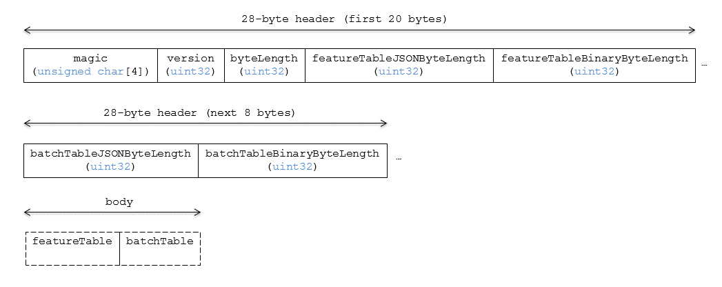
- Tile with a header TileHeader and a body TileBody
- TileHeader represents the first 28 bytes (magic value, version, ...)
- TileBody contains the feature table FeatureTable and the batch table (not supported for now)
- FeatureTable with a header FeatureTableHeader and a FeatureTableBody
- FeatureTableBody which contains features of type Feature
Moreover, a utility class TileReader is available to read a .pnts file as well as a simple command line tool to retrieve basic information about a Point Cloud file py3dtiles_info.
How to read a .pnts file
>>> from py3dtiles import TileReader
>>>
>>> filename = 'tests/pointCloudRGB.pnts'
>>>
>>> # read the file
>>> tile = TileReader().read_file(filename)
>>>
>>> # tile is an instance of the Tile class
>>> tile
<py3dtiles.tile.Tile>
>>>
>>> # extract information about the tile header
>>> th = tile.header
>>> th
<py3dtiles.tile.TileHeader>
>>> th.magic_value
'pnts'
>>> th.tile_byte_length
15176
>>>
>>> # extract the feature table
>>> ft = tile.body.feature_table
>>> ft
<py3dtiles.feature_table.FeatureTable
>>>
>>> # display feature table header
>>> ft.header.to_json()
{'RTC_CENTER': [1215012.8828876738, -4736313.051199594, 4081605.22126042],
'RGB': {'byteOffset': 12000}, 'POINTS_LENGTH': 1000, 'POSITION': {'byteOffset': 0}}
>>>
>>> # extract positions and colors of the first point
>>> f = ft.feature(0)
>>> f
<py3dtiles.feature_table.Feature>
>>> f.positions
{'Y': 4.4896851, 'X': 2.19396, 'Z': -0.17107764}
>>> f.colors
{'Green': 243, 'Red': 44, 'Blue': 209}
How to write a .pnts file
To write a Point Cloud file, you have to build a numpy array with the corresponding data type.
>>> from py3dtiles import Feature
>>> import numpy as np
>>>
>>> # create the numpy dtype for positions with 32-bit floating point numbers
>>> dt = np.dtype([('X', '<f4'), ('Y', '<f4'), ('Z', '<f4')])
>>>
>>> # create a position array
>>> position = np.array([(4.489, 2.19, -0.17)], dtype=dt)
>>>
>>> # create a new feature from a uint8 numpy array
>>> f = Feature.from_array(dt, position.view('uint8'))
>>> f
<py3dtiles.feature_table.Feature>
>>> f.positions
{'Y': 2.19, 'X': 4.489, 'Z': -0.17}
>>>
>>> # create a tile directly from our feature. None is for "no colors".
>>> t  = Tile.from_features(dt, None, [f])
>>>
>>> # the tile is complete
>>> t.body.feature_table.header.to_json()
{'POINTS_LENGTH': 1, 'POSITION': {'byteOffset': 0}}
>>>
>>> # to save our tile as a .pnts file
>>> t.save_as("mypoints.pnts")
How to use py3dtiles_info
If we want to retrieve basic information about the file mypoints.pnts previously created:
$ py3dtiles_info mypoints.pnts
Tile Header
-----------
Magic Value:  pnts
Version:  1
Tile byte length:  88
Feature table json byte length:  48
Feature table bin byte length:  12

Feature Table Header
--------------------
{'POINTS_LENGTH': 1, 'POSITION': {'byteOffset': 0}}

First point
-----------
{'Y': 2.1900001, 'X': 4.4889998, 'Z': -0.17}